Deliver mass notifications and alerts to mobile users within areas of interest
The Location-based SMS technology allows governments, public agencies and mobile operators to send SMS notifications and warnings to mobile subscribers located in a specific geographical area of interest. As an option, the solution can also provide in real time the location of mobile users.
Reliable location data build-up via active/passive network integration
Reliable location data build-up via active/passive network integration
Opencode Location-based SMS Broadcast (LB-SMS) uses real-time probes and look-ups of the MNO’s radio and core network to gather and store information in dedicated Location Databases. Opencode LB-SMS can be used as number of different solutions – to create location-based marketing campaigns, to broadcast emergency alerts in case of a disaster or to monitor subscriber movement. The solution comes with an intuitive user interface that enables seamless campaign and alert creation as well as platform management.
Creation of Geofences/Virtual Areas and real-time tracking Heatmaps
Creation of Geofences/Virtual Areas and real-time tracking Heatmaps
Opencode LB-SMS allows platform owners to easily create geofences and if required combine geofences of different locations into a single virtual area of interest. The system interface can show heatmaps where the platform owner could track in real time the location of the mobile users in a particular area of interest/geofence.
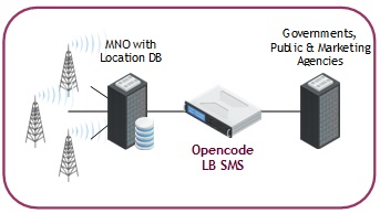
Example of Integration:

Highlighted features:
- 2G, 3G, 4G, 5G network support
- 100% mobile user coverage
- Own MAP, BSSAP, RANAP, S6a, S6c & Diameter protocol stacks
- Supports geo-tracking & geo-fencing
- High-availability
- Geo-redundancy
- User-friendly web GUI front-end
- Integrated SMSC
- Active/Passive tracking
- Supports CAP v1.2
- Multi-language support
- Over-a-map (GIS) definition of virtual areas


